Navionics Plus Regular Down Load - DWL001 - Blank regular
Navionics Gold charts have been replaced by Navionics+ charts. These cover the same areas but also offer the possibility for downloading SonarChart™ and Community Edits
Small Navionics +
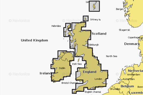
Many of the products we sell come with a small Navioncs + Chart. We supply a blank micro SD card with a SD card holder and USB stick. The Card has a lisence on it alowing you to download a small Navionics + area. The UK for example is made up of 11 small areas listed below. The downloads feature all of the Navionics + Feaures - Nautical Chart - SonarChart -Community Edits - Daily Updates - Dock-to-dock Autorouting - SonarChartTM Live - Advanced Map Options and Plotter Sync (proveded the unit you put it in surports them).
UK & Ireland Inland - Inland Waterways
All-in-one max detailed cartography for marine and lakes makes Navionics+ the perfect choice for cruising, fishing and sailing. Get the most accurate navigational data for your GPS plotter, an exclusive 0.5 m HD bathymetry map which is enhanced by boaters like you, and unique local content shared by Navionics app users. We make thousands of edits every day, so you can always have the most current charts. Daily updates and advanced features are included for one year.
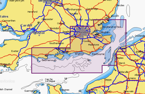
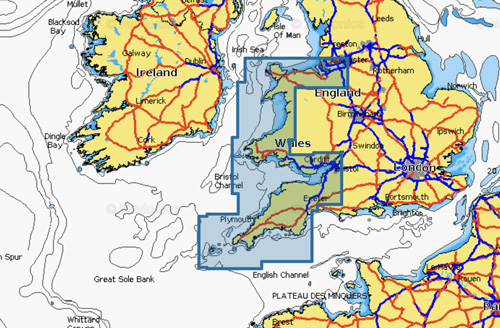
Portland to Walton-on-the-Naze
All-in-one max detailed cartography for marine and lakes makes Navionics+ the perfect choice for cruising, fishing and sailing. Get the most accurate navigational data for your GPS plotter, an exclusive 0.5 m HD bathymetry map which is enhanced by boaters like you, and unique local content shared by Navionics app users. We make thousands of edits every day, so you can always have the most current charts. Daily updates and advanced features are included for one year.
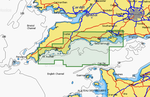
Falmouth to Chichester
All-in-one max detailed cartography for marine and lakes makes Navionics+ the perfect choice for cruising, fishing and sailing. Get the most accurate navigational data for your GPS plotter, an exclusive 0.5 m HD bathymetry map which is enhanced by boaters like you, and unique local content shared by Navionics app users. We make thousands of edits every day, so you can always have the most current charts. Daily updates and advanced features are included for one year.
Liverpool to Exmouth
All-in-one max detailed cartography for marine and lakes makes Navionics+ the perfect choice for cruising, fishing and sailing. Get the most accurate navigational data for your GPS plotter, an exclusive 0.5 m HD bathymetry map which is enhanced by boaters like you, and unique local content shared by Navionics app users. We make thousands of edits every day, so you can always have the most current charts. Daily updates and advanced features are included for one year.
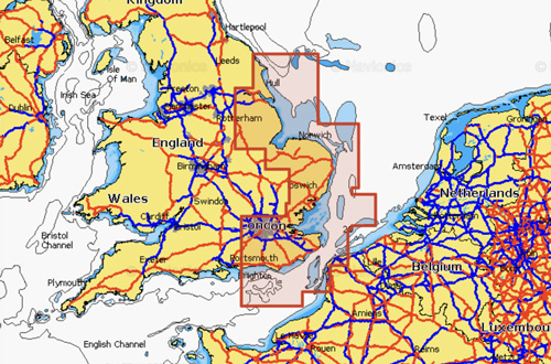
Littlehampton to Scarborough
All-in-one max detailed cartography for marine and lakes makes Navionics+ the perfect choice for cruising, fishing and sailing. Get the most accurate navigational data for your GPS plotter, an exclusive 0.5 m HD bathymetry map which is enhanced by boaters like you, and unique local content shared by Navionics app users. We make thousands of edits every day, so you can always have the most current charts. Daily updates and advanced features are included for one year.
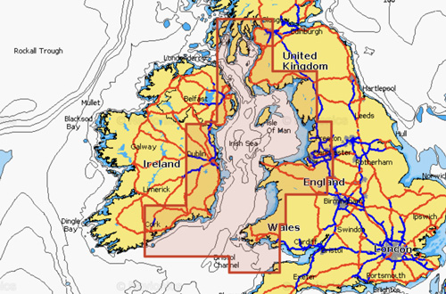
Irish Sea and Scotland South West
All-in-one max detailed cartography for marine and lakes makes Navionics+ the perfect choice for cruising, fishing and sailing. Get the most accurate navigational data for your GPS plotter, an exclusive 0.5 m HD bathymetry map which is enhanced by boaters like you, and unique local content shared by Navionics app users. We make thousands of edits every day, so you can always have the most current charts. Daily updates and advanced features are included for one year.
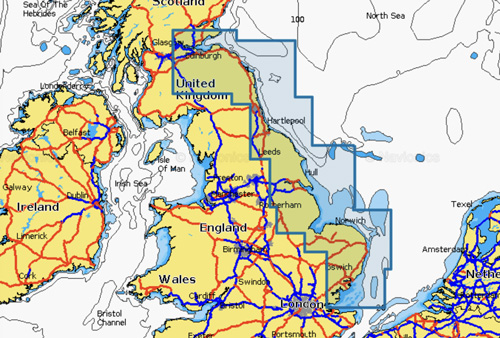
Southend to Anstruther
All-in-one max detailed cartography for marine and lakes makes Navionics+ the perfect choice for cruising, fishing and sailing. Get the most accurate navigational data for your GPS plotter, an exclusive 0.5 m HD bathymetry map which is enhanced by boaters like you, and unique local content shared by Navionics app users. We make thousands of edits every day, so you can always have the most current charts. Daily updates and advanced features are included for one year.
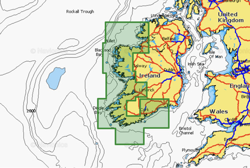
Waterford to Aran Island
All-in-one max detailed cartography for marine and lakes makes Navionics+ the perfect choice for cruising, fishing and sailing. Get the most accurate navigational data for your GPS plotter, an exclusive 0.5 m HD bathymetry map which is enhanced by boaters like you, and unique local content shared by Navionics app users. We make thousands of edits every day, so you can always have the most current charts. Daily updates and advanced features are included for one year.
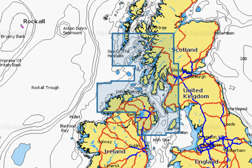
Ireland North, Scotland West
All-in-one max detailed cartography for marine and lakes makes Navionics+ the perfect choice for cruising, fishing and sailing. Get the most accurate navigational data for your GPS plotter, an exclusive 0.5 m HD bathymetry map which is enhanced by boaters like you, and unique local content shared by Navionics app users. We make thousands of edits every day, so you can always have the most current charts. Daily updates and advanced features are included for one year.
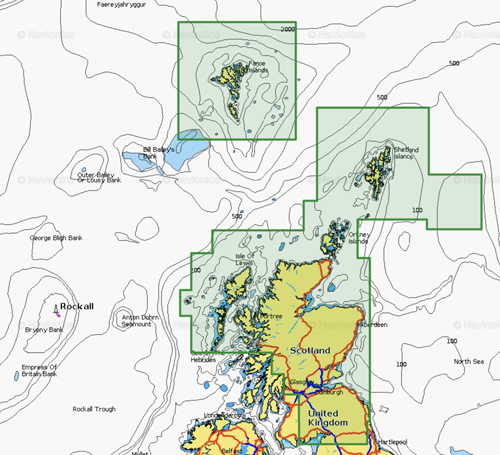
Scotland North and East, Faroe Islands
All-in-one max detailed cartography for marine and lakes makes Navionics+ the perfect choice for cruising, fishing and sailing. Get the most accurate navigational data for your GPS plotter, an exclusive 0.5 m HD bathymetry map which is enhanced by boaters like you, and unique local content shared by Navionics app users. We make thousands of edits every day, so you can always have the most current charts. Daily updates and advanced features are included for one year.

Ile De Batz-Carentan
All-in-one max detailed cartography for marine and lakes makes Navionics+ the perfect choice for cruising, fishing and sailing. Get the most accurate navigational data for your GPS plotter, an exclusive 0.5 m HD bathymetry map which is enhanced by boaters like you, and unique local content shared by Navionics app users. We make thousands of edits every day, so you can always have the most current charts. Daily updates and advanced features are included for one year.