



Garmin
Navionics+ U.K., Ireland & Holland - Marine Charts - NAEU628L
Pickup available at Mercury Yacht Harbour
Usually ready in 2-4 days
Description
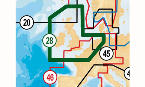
Garmin Navionics+ marine charts covering the United Kingdom, Ireland, Belgium and upper north-east France, including the Hebrides, Shetland Islands, Orkney Islands, Isle of Man, Cardigan Bay, the Bristol Channel, the English Channel, the Strait of Dover and Amsterdam. The card combines nautical charts with integrated Auto Guidance technology, Dock-to-dock autorouting, depth-range shading and community edits for cruising, fishing and sailing.
Supplied on a microSD/SD card with one year of daily chart updates from activation, downloadable through the Navionics Boating app.
Navionics+ and Navionics Platinum+ cards are not compatible with Garmin chartplotters; check your chartplotter's Navionics compatibility before ordering.
PRODUCT DETAILS
- Coverage of UK, Ireland, Belgium and north-east France
- Region code NAEU628L
- Auto Guidance and Dock-to-dock autorouting
- Depth-range shading and community edits
- One year of chart updates from activation
- Not compatible with Garmin chartplotters
No exploded diagram available for this product.
No compatible transducers listed for this product.
No spares or accessories listed for this product.
No compatible products found.
Cartography
| Product line | Navionics+ |
| Coverage area | UK and Ireland |
| Region code | NAEU628L |
| Media | microSD/SD card |
| Updates | One year of chart updates from activation |
Compatibility
| Compatibility | Navionics+ and Navionics Platinum+ cards are not compatible with Garmin chartplotters; check your chartplotter's Navionics compatibility before ordering. |
No videos available for this product.
No downloads available for this product.
No frequently asked questions for this product.


